Crossposted at Daily Kos
I've always loved geography. From the moment my mom gave me the old National Geographic Atlas I was hooked on maps. Coupled with a healthy love for meteorology and other Earth Sciences it's been a match made in heaven. I love geography so much that I even majored in it for undergrad. And my future degree or degrees will definitely be in the field of geography
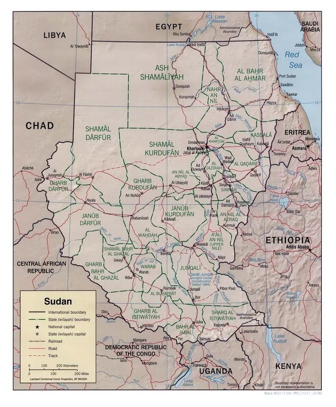
Having said all that, it makes me sad, actually angry, about the sad sad state of American geographic education. And having said that, I've decided to do my small part to help rectify this sin. Make the jump, and have your first geography lesson on a very hot spot of the world: Sudan and its three federal states in Darfur.
Sudan, as we all know, is home to Darfur, a region wrecked by war and genocide. Kossack Alegre has been leading the fight about Darfur and sadly, her diaries have not received the notice that they need. I got to thinking, “Maybe people aren't commenting because they don't know anything about Darfur. They don't know the geography. They don't know where it is.” Thus was born DKos Atlas.
The Basics by the Numbers:
Population
41,236,378 (July 2006 est.) - note that the UN estimates a population of 37 million (wikipedia)
Total fertility rate:
4.72 children born/woman (2006 est.)
Nationality:
noun: Sudanese (singular and plural)
adjective: Sudanese
Ethnic groups:
black 52%, Arab 39%, Beja 6%, foreigners 2%, other 1%
Religions:
Sunni Muslim 70% (in north), indigenous beliefs 25%, Christian 5% (mostly in south and Khartoum)
Languages:
Arabic (official), Nubian, Ta Bedawie, diverse dialects of Nilotic, Nilo-Hamitic, Sudanic languages, English
note: program of "Arabization" in process
Literacy:
definition: age 15 and over can read and write
total population: 61.1%
male: 71.8%
female: 50.5% (2003 est.)
-CIA World Factbook
Physical Geography: By the Numbers:
Location:
Northern Africa, bordering the Red Sea, between Egypt and Eritrea
Geographic coordinates:
15 00 N, 30 00 E
Area:
total: 2,505,810 sq km
land: 2.376 million sq km
water: 129,810 sq km
Area - comparative:
slightly more than one-quarter the size of the US
Land boundaries:
total: 7,687 km
border countries: Central African Republic 1,165 km, Chad 1,360 km, Democratic Republic of the Congo 628 km, Egypt 1,273 km, Eritrea 605 km, Ethiopia 1,606 km, Kenya 232 km, Libya 383 km, Uganda 435 km
Coastline:
853 km
Maritime claims:
territorial sea: 12 nm
contiguous zone: 18 nm
continental shelf: 200-m depth or to the depth of exploitation
Climate:
tropical in south; arid desert in north; rainy season varies by region (April to November)
Terrain:
generally flat, featureless plain; mountains in far south, northeast and west; desert dominates the north
Elevation extremes:
lowest point: Red Sea 0 m
highest point: Kinyeti 3,187 m
Natural resources:
petroleum; small reserves of iron ore, copper, chromium ore, zinc, tungsten, mica, silver, gold, hydropower
Land use:
arable land: 6.78%
permanent crops: 0.17%
other: 93.05% (2005)
Irrigated land:
18,630 sq km (2003)
Natural hazards:
dust storms and periodic persistent droughts
Environment - current issues:
inadequate supplies of potable water; wildlife populations threatened by excessive hunting; soil erosion; desertification; periodic drought
Environment - international agreements:
party to: Biodiversity, Climate Change, Climate Change-Kyoto Protocol, Desertification, Endangered Species, Law of the Sea, Ozone Layer Protection
signed, but not ratified: none of the selected agreements
Geography - note
largest country in Africa; dominated by the Nile and its tributaries
CIA World Factbook
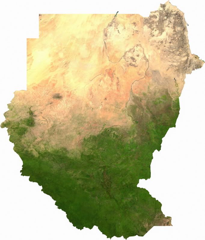
Sudan's physical geography plays a big part to its internal conflicts. In the north is desert. In the equatorial south are swamps and other arable lands. Between the two is the Sahel, a region of not quite grassland but not quite arid desert area that stretches across the continent of Africa. Recently, the Sahara has steadily been growing south, eating into the Sahel. The Sahel is an interesting region to be sure.
Sudan lies west of the Great Rift Valley. Eventually, in several tens of millions of years, the Great Rift Valley which runs the length of East Africa will open up into a new sea.
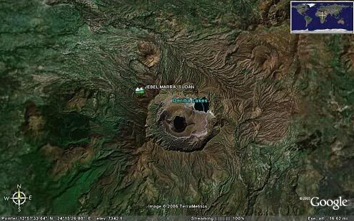
Even though Sudan is not on the plate boundary, there are several fairly recent volcanic zones, including Jebbel Marra in the Darfur region.
Summit Elev: 3042 m
Latitude: 12.95°N
Longitude: 24.27°E
The most prominent feature of the vast Jebel Marra volcanic field, located in the Darfur province of western Sudan, is the youthful Deriba caldera. The 5-km-wide, steep-walled caldera, located at the southern end of the volcanic field, was formed about 3500 years ago at the time of the eruption of voluminous airfall pumice and pyroclastic flows that traveled more than 30 km from the volcano. The Jebel Marra volcanic field covers a broad area of the Marra Mountains and contains early basaltic lava flows overlain by thick sequences of pyroclastic-flow deposits. The northern part of the volcanic field displays trachytic lava plugs and spines forming residual inselbergs and young basaltic scoria cones and lava flows. Ash eruptions at Deriba caldera may have continued into early historical time (Burton and Wickers, 1966), and fumarolic activity has been observed on the flanks of a small pyroclastic cone within the caldera.
Sudan is also dominated by the Nile River. In the northern areas of the nation, the Nile is the only freshwater available. At the border of Sudan and Egypt the Nile spreads out due to the impoundment of the Aswan High Dam several hundred miles to the north in Egypt.
The Nile is actually two rivers. The White Nile, which stretches all the way into East Central Africa and the Blue Nile, which rises at Lake Tana in Ethiopia. They meet (called a confluence) at Khartoum. The meeting is dramatically shown in this image. The clearer, bluer waters of the Blue Nile mix with the murkier grayish waters of the White Nile. The area between the river south of Khartoum supports the nations agricultural industries. With so little of the nation able to be farmed due to the climate, every bit that is able to be is used. This has sparked conflict innumerable as we shall see and discuss.
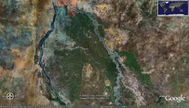
The map above is the area south of Khartoum between the Blue and White Nile rivers
A Brief History
Sudan has a very long and varied history, stretching back beyond the days of the Ancient Egyptians and the Pharaohs. Humanity settled in the Nile Valley long long before those days. Empires rose and fell. However for the sake of brevity we're going to discuss Modern Sudan.
The British are to blame here, one could say, as Sudan was a major East African colony of theirs. They ruled the Sudan as two seperate entities: North Sudan and South Sudan. South Sudan, largely home to black African Christians, was ruled as English speaking. Southern Sudan religion is also largely an amalgamation of Christianity and Animist traditions. The central city is Juba . North Sudan, culturally (though not necessarily) Arabic in nature and Muslim, was ruled as Arabic speaking. Until independence, this is how Sudan was run.
When independence came, civil war broke out. The Northerner's were wealthier, and the Southerners felt they would be dominated by North Sudan. This is what ended up happening, and the first civil war lasted from independence in 1956 to 1972. 500,000 people died. Grievances were not assured, however and situations grew worse as the Arabic speaking north continued to dominate southern affairs, instituting Sharia Law, banning political parties, and the like. A second civil war broke out in 1983 and it lasted until 2005. Two million people died, and 4 to 6 million people were left as refugees within Sudan and out into its borders, spreading instability to neighboring nations. The South won, so to speak, as they have gained the autonomy they desired. It remains to be seen if they will remain part of Sudan, or secede and form a new nation.
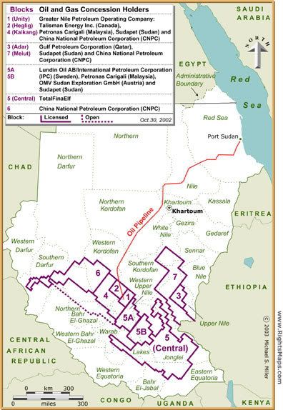
Note: Much of Sudan's oil wealth lies in the southern part of the nation. .
DARFUR
Sudan is still not stable even after this civil war. There remains the question and problem of Darfur.
What, and where, is Darfur?
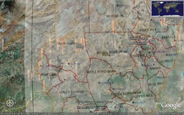
Darfur (Arabic: “Home of the Fur”) is comprised of Sudan's three western states bordering the nations of Libya, Chad, and the Central African Republic. Wikipedia's Darfur article, from which much of this section is drawn among other areas on the internets, explains the physical geography and climate better then I could.
Darfur covers an area of some 493 180 km² (196,555 miles²)—about three-quarters the size of Texas, more than half the size of Kenya or slightly smaller than France. It is largely an arid plateau with the Marrah Mountains (Jebel Marra), a range of volcanic peaks rising up to 3000 m (10,100 ft), in the center of the region. The region's main towns are Al Fashir, Nyala, and Geneina.
There are four main features of the physical geography. The whole eastern half of Darfur is covered with plains and low hills of sandy soils, known as goz, and sandstone hills. In many places the goz is waterless and can only be inhabited where there are water reservoirs or deep boreholes. While dry, goz may also support rich pasture and arable land. To the north the goz is overtaken by the desert sands of the Sahara. A second feature are the wadis, seasonal watercourses ranging from small rivulets that flood only occasionally during the wet season to large wadis that flood for most of the rains and flow from western Darfur hundreds of miles west to Lake Chad. Many wadis have pans of alluvial deposit with rich soil that are also difficult to cultivate. The west of Darfur is dominated by the third feature, basement rock, sometimes covered with a thin layer of sandy soil. Basement rock is too infertile to be farmed, but provides sporadic forest cover that can be grazed by animals. The fourth and final feature are the Marrah Mountains, volcanic plugs created by a massif, that rise up to a peak at Deriba crater where there is a small area of temperate climate, high rainfall and permanent springs of water.
The rainy season is from June to September, transforming much of the region from dusty brown to verdant green. As much of the population of Darfur is agricultural, the rains are vital. In normal years, millet, a mainstay crop is ready to be harvested by November. Once harvested, the dry stalks may be fed to domestic livestock. In the far northern desert, years may pass between rainfall. In the far south, annual average rainfall is 700 mm and many trees remain green year-round.[1]
Wadis, for the record, are just like Arroyos in the Southwest or gullies and gulches in Appalachia. It's the Arabic equivalent of the concept.
Darfur is home to several tribes, however the tribe that Darfur is named for is the Fur. They number roughly 500,000 and live a sedentary lifestyle in the areas of the region that are best suited for agriculture. This has led to many a conflict, as we will see.
Some History in Darfur
I could gloss over this section and simply state “this is something outsiders just can't understand,” but that would not bring help and justice to the people of Darfur. Bear with me, and take close notes.
Darfur is fairly isolated. It has also been largely ignored by governments, be it the Egyptians, the British, or even the Sudanese after independence.
At one time Darfur was an independent region. The Keira Dynasty ruled the area under the Islamic Sultanate of Darfur. The British-Sudanese colonial government ended the dynasty and absorbed the region in 1916.
Since then, noone has paid any real attention to Darfur. The British and later Sudanese devoted their national resources and efforts to those living in the valleys of the Blue and White Nile, a grievance held by the Sudanese living in the South as well.
After independence, certain politicians and certain political parties used Darfur as their issue, pitting the residents against the central government to gain their electoral votes while not doing a damn thing to help the residents out themselves. We know this tactic well. It's what's the matter with Kansas.
They (the party in question being the Umma Party) pitted the black residents of Darfur against the largely Arab residents living in the Nile Valleys near Khartoum, where much of the nation's resources were being spent. In short, the politicians in Khartoum pitted African versus Arab, and traditionally, this was not the way things were done. But it worked. And Libya made it worse by manipulating the situation with a dream of a pan-Arab state stretching across the Sahel in Africa. Continued manipulations by Qaddafi, Chadian leadership (which has almost always been weak since its independence) and Sudanese leadership in Khartoum put Darfur in the middle, with militias and other groups being used for proxy wars against the others.
This structural inequity, complete with internal and external political manipulation, has built and built through the 1970s and 1980s (even as the central government was increasingly distracted by war and famine in the South), and the Central government also preferred certain tribes over others. They generally did not prefer the dominant tribe in Darfur, and when a famine broke out in the mid 80s in Darfur (a famine that killed many, many more across east and central Africa), 95,000 Darfuris died. Some walked to Khartoum and were promptly declared non citizens and expelled to refugee camps.
One point of confusion about this conflict, used often to bash Muslims as evil, is that this conflict is about Arab Muslims and Black Christians. This is not entirely true, as more often then not the Janjaweed militias are Black Muslims and their victims are also Black Muslims. What the effects of the proxy wars between Chad, Libya and the central government in Khartoum along with the manipulations of the political parties have had is they've created situations where some of the locals see themselves as Pan Arab revolutionaries, or reactionary “Anti-Africans.” And the Sudanese government used this to its advantage, in very much the way the Republicans use their own fundamentalist base to discriminate against America's gay population.
As we can see, this picking and prodding at this scab of local hatreds grew infected and like a big nasty pus-filled zit, it blew up in the face of the Sudanese government.
Darfur Aflame
In 1991, one of the main opposition groups in the civil war entered Darfur. In reprisal, the Sudanese government (with their Janjaweed backers) burned Fur villages in reprisal. This was one of the first instance of what would, in 12 years time, become a genocide.
In 1994, the Darfur region was divided into the three federal states you see today. This was, in much the way our congressional districts are gerrymandered, designed to ensure Islamist candidates and further marginalize the Fur tribe.
This oppression came to a head in 2003, when the Justice and Equality Movement and Sudanese Liberation Army began attacks. In that year, on the 25th of April, the JEM and the SLA attacked a base at al-Fashir (the capital of the state of North Darfur), killing 75. The attack stunned the leadership in Khartoum. Shortly there after the SLA and JEM continued their victories against the Sudanese Army. And then the reprisals were launched.
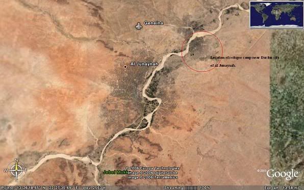
The Junjaweed, simmering in their stew of hatred for Africans (even though they were and are African themselves!) and revved up in their revolutionary fervor for Pan-Arabia, were unleashed on the Darfuri population. This was not the first time the Sudanese government had unleashed the Junjaweed militias. They had done the same in 1996 with another revolt, and also had used them in the southern oil fields during the civil war with the same results we see in Darfur this very day. To date, 400,000 have been estimated to have been killed in this dry region in the west of Sudan. Hundreds of thousands more displaced internally and externally to the neighboring nation of Chad (causing instability in that country as well.) Some are living in large camps, documented by USAID. Here's the city of Al Junayah in West Darfur, near the Chadian border. A large camp is located to the north and east of the city.
You can see in the following images the destruction. Villages burnt to the ground, soon to return to the sands of the Sahel.
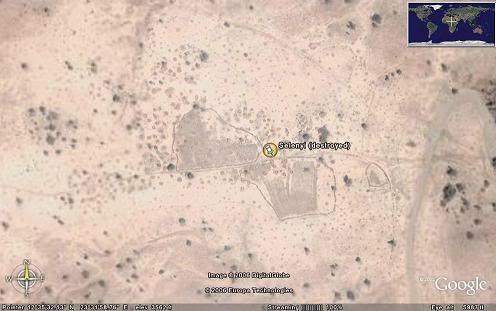
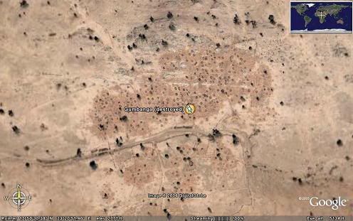
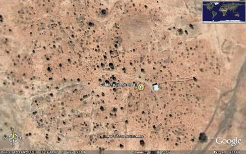
the circles you see are huts that have been burned. Only the foundations remain. A larger version of the Selenyi village image can be seen here. These images are available in Google Earth.
A full size map of the scale of villages destroyed is available here.
Proper Credit must go to the following sources:
The CIA World Handbook for statistics
Wikipedia's extensive articles on Sudan and Darfur
USAID Sudan's images of aerial photos of refugee camps
The University of Texas's Map Library, a site that makes me drool every day.
Now, go see what you can do to help Darfur.
2 comments:
I found your blog on Google when researching for an online geography class PowerPoint project. We picked the Darfur crisis and geography's role in it.
OMG, the stuff the world ignores....! I have learned that, just by taking this class (which I later found out I didn't need for my major/gen. ed. credits).
People really do need to be informed. There's no reason for fortunate people like us in the U.S. to be so ignorant to things like this, when there are this many people suffering for such stupid reasons!
Good luck :)
~ Lori, former Central PA resident now in TN
Thanks for sharing your knowledge. People around the world must know about this.
Greetings from México.
Post a Comment